Tuesday, August 31, 2010

Supreme Court reopens Bhopal gas tragedy case

http://world-worst-disasters.blogspot.com/
7 Indians, who were executives of Union Carbide, and were sentenced to two years in jail for their role in the Bhopal Gas Tragedy of 1984 could soon be looking at tougher charges.

The Supreme Court has reopened the Bhopal case on the basis of a curative petition filed by the CBI which asks the court to reconsider its earlier decision, in 1996, in which it diluted charges against former Union Carbide India Chairman Keshub Mahindra and 6 others from culpable homicide not amounting to murder to criminal negligence.

The former Carbide men will now have to answer why the charges against them should not be beefed up.

The top court was hearing a curative petition filed by the CBI which wanted a reconsideration of the 1996 judgement which diluted charges against former Union Carbide India Chairman Keshub Mahindra and 6 others. The petition is silent on Warren Anderson, the then Union Carbibe President.

View Full Story

Monday, August 30, 2010

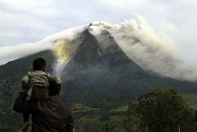
Thousands flee as Sumatra volcano erupts

http://world-worst-disasters.blogspot.com/A LONG-dormant Indonesian volcano has erupted for the second day in a row, spewing out towering clouds of ash and forcing the evacuation of more than 21,000 people.

Reports said 2 people had died, while thousands had been forced to flee their homes after Mount Sinabung in northern Sumatra spewed a vast cloud of smoke and ash high into the air. Airlines were warned to avoid the remote mountain as it erupted for a second day after springing to life for the first time in four centuries.

CNN reported on its site that 2 people had died.

"The 2 people died because of heart attack and respiratory complication," said Priyadi Kardono of the National Disaster Co-ordination Agency, according to CNN.

"We have sent food and gas masks for the rest of the displaced people."

View Full Story

Thursday, August 26, 2010

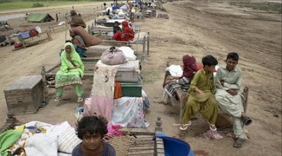
Pakistanis flee new monsoon floods in south

http://world-worst-disasters.blogspot.com/
Thousands of Pakistanis are fleeing their homes in southern coastal areas as floods sweep down from the north.

Some 200,000 people have been evacuated in the Thatta area of Sindh province, where dozens of villages are submerged.

In the north, workers have begun clearing up as the floods recede. The UN has appealed for more helicopters to reach 800,000 people who are cut off.

Doctors in many areas are struggling to cope with the spread of water-borne diseases such as diarrhoea and cholera.

5 million Pakistanis have no shelter, and urgently need tents or plastic sheeting to protect them from the sun.

The UN says more than 17 million people have been affected by the monsoon floods, and about 1.2 million homes have been destroyed.

View Full Story

Wednesday, August 25, 2010

UN sees Niger food crisis as "a disaster in the making"

http://world-worst-disasters.blogspot.com/
UNITED NATIONS, Aug. 24, 2010 -- Sounding the alarm on Niger 's ongoing food crisis, the head of the World Food Program (WFP) Josette Sheeran and UN humanitarian chief John Holmes have repeatedly raised the issue as an underfunded "disaster in the making," UN spokesman Martin Nesirky told reporters here on Tuesday.

Recent flooding threatens to exacerbate an already dire situation, as Niger's population of 15 million people continue to face severe food shortages and high malnutrition rates due to prolonged drought.

Bettina Luescher, chief spokesperson for the World Food Program, told Xinhua in a Tuesday phone interview that aid efforts continue to focus on those most vulnerable to the food shortages, due to lack of full funding.

"(The WFP) is concentrating on children under 5 and their families," said Luescher. "We’re bringing food rations to 670,000 children and their families, comprising a total of 5 million people," she added.

View Full Story

Monday, August 23, 2010

World Worst Disasters : Tropical storm approaches southern China island amid nationwide rain disasters

http://world-worst-disasters.blogspot.com/
HAIKOU, Aug. 23 -- China is bracing for a strong tropical storm named "Mindelle", which is expected to skim the southernmost island province of Hainan between Monday midnight and Tuesday morning.

At 8 a.m. Monday, a tropical low pressure system across the South China Sea intensified into the 5th tropical storm of the year, after being upgraded to a strong tropical storm eight hours later.

The storm, by the name of "Mindellu", which means dandelion in Korean, is likely to approach the Beibu Gulf off the southern Guangxi Zhuang Autonomous Region after skipping Hainan, the Hainan provincial meteorological bureau said.

Local authorities in Hainan have halted railway, shipping services and tourism programs and called fishing boats to return to ports as they braced for the storm.

Both cargo as well as passenger shipping services were halted at 5 p.m., according to the ban issued by the provincial maritime affairs bureau.

View Full Story

Sunday, August 22, 2010

Cholera claims more lives in Bauchi - 70 dead; 1,742 infected

http://world-worst-disasters.blogspot.com/
Just as some countries around the world are battling disasters of varying proportions, the people of Bauchi State seem to be fighting their own demon as cholera outbreak continues to claim the lives of its people. Ishola Michael reports.

In Bauchi State not fewer than 70 people including children have thus far died following an outbreak of cholera in some local government areas of the state, just as 1,742 persons have been infected and are lying critically ill at the various health centres across the state and this development sent shivers down the spines of many who are doing everything humanly possible to ward off the disease.

While speaking to newsmen on the issue, the chairman of the State Primary Health Care Developmental Agency, Dr. Musa Dambam Mohammed, lamented that the fatalities of this year’s outbreak were far higher than previous years due to what he described as negligence on the part of the people, particularly the relatives of those infected who refused to take the infected to the nearest health care facilities for medical attention, but will rather treat them at home until the situation got out of hand.

View Full Story

Thursday, August 19, 2010

EXTRA: Ban: Pakistan's flood disasters a 'slow-motion tsunami'


New York - Floods have created an emergency situation for 15 to 20 million people in Pakistan, impacting more than the combined population hit by the Indian Ocean tsunami and earthquakes in Pakistan-administered Kashmir and Haiti, UN Secretary General Ban Ki- moon said Thursday.

"Pakistan is facing a slow-motion tsunami," Ban said in an address to the UN General Assembly, convened to nudge the world into providing relief aid to flood victims.

"Its destructive powers will accumulate and grow with time," Ban warned as weather forecasts called for four more weeks of monsoon rain, which will add to the flood problems.

Ban personally visited Pakistan last weekend to get a first-hand look at the damage caused by the floods and its impact on the people.

The tsunami in 2004 hit Indonesia and many Southeast and South Asian nations. Massive earthquakes hit Pakistan-administered Kashmir in 2005 and Haiti in 2010. More than 200,000 people died in Haiti.

When the waters will finally recede, Pakistan would need one billion dollars to rebuild its agriculture, based on a World Bank estimate, Ban said.

"In the long term, the huge damage to infrastructure must be repaired - schools, hospitals, irrigation canals, communications, transport links," Ban said.

At least 160,000 square kilometers of Pakistan are covered with flood waters, an area larger than more than half of countries of the world.

Wednesday, August 18, 2010

Natural disasters likely to continue

http://world-worst-disasters.blogspot.com/
BEIJING, Aug. 19 -- Recalling the nightmare early on Wednesday, Yang Guihua did not want to believe it was true.

The mudslide destroyed the 34-year-old's house in Migu village, Puladi township of Gongshan Derung-Nu autonomous county in Southwest China's Yunnan province, leaving her 9-year-old son missing.

"The downpour, coupled with howling wind, was terrifying. My daughter, son and I did not dare to sleep. But the mudslide took away my son anyway," she said with a trembling voice.

At least 67 people are missing and 38 were injured, 10 severely, after mudslides hit the remote town in northwestern Yunnan early Wednesday.

The majority of the missing people are either employees of the Yujin Iron Mine or villagers in the Puladi township, where the mudslides struck at about 1:30 am.

View Full Story

Tuesday, August 17, 2010

Fresh flood alert for upper Sindh

http://world-worst-disasters.blogspot.com/
ISLAMABAD (Agencies) – Due to high flow of water in Indus River, upper Sindh towns including ShahdadKot, Sajawal, Ratodero and Qabo Saeed Khan have been declared red zone.

Floods have turned their directions towards Keerthar Canal in Jacobabad after water was seen flowing backwards due to destruction of gates located at Karang Regulator near Shahdadkot, reported a private TV channel.

DCO Shahdadkot ordered evacuation of 150 villages including Qabo Saeed Khan on emergency basis after the district was alerted against potential flooding.

A massive flood is marching towards Larkana and Khairpur districts after a huge crack was developed in under-construction security bund, aimed at turning direction of River Indus away from population in both the districts. The residents of 2 villages near Jhirik, Rajoo Nizamani and Tando Hafiz Shah of katcha areas in Thatta district have been warned to evacuate towards safer places in view of the expected super flood to pass from here this week.

View Full Story

Monday, August 16, 2010

Hurricane Katrina


Hurricane Katrina
Category 5 hurricane ( SSHS)
http://world-worst-disasters.blogspot.com/

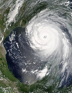
Hurricane Katrina near peak strength on August 28, 2005
FormedAugust 23, 2005
DissipatedAugust 30, 2005
Highest
winds
175 mph (280 km/h) (1-minute sustained)
Lowest pressure902 mbar (hPa; 26.64 inHg)
Fatalities1,836 confirmed[1]
Damage$81.2 billion (2005 USD) $90.1 billion (2010 USD)(Costliest hurricane in US history)
Areas
affected
Bahamas, South Florida, Cuba, Louisiana (especially Greater New Orleans), Mississippi, Alabama, Florida Panhandle, most of eastern North America
Part of the2005 Atlantic hurricane season
Hurricane Katrina of the 2005 Atlantic hurricane season was the costliest natural disaster, as well as one of the five deadliest hurricanes, in the history of the United States. Among recorded Atlantic hurricanes, it was the sixth strongest overall. At least 1,836 people lost their lives in the actual hurricane and in the subsequent floods, making it the deadliest U.S. hurricane since the 1928 Okeechobee hurricane; total property damage was estimated at $81 billion (2005 USD), nearly triple the damage wrought by Hurricane Andrew in 1992.

http://world-worst-disasters.blogspot.com/
Hurricane Katrina formed over the Bahamas on August 23, 2005 and crossed southern Florida as a moderate Category 1 hurricane, causing some deaths and flooding there before strengthening rapidly in the Gulf of Mexico. The storm weakened before making its second landfall as a Category 5 storm on the morning of Monday, August 29 in southeast Louisiana. It caused severe destruction along the Gulf coast from central Florida to Texas, much of it due to the storm surge. The most severe loss of life occurred in New Orleans, Louisiana, which flooded as the levee system catastrophically failed, in many cases hours after the storm had moved inland. Eventually 80% of the city and large tracts of neighboring parishes became flooded, and the floodwaters lingered for weeks. However, the worst property damage occurred in coastal areas, such as all Mississippi beachfront towns, which were flooded over 90% in hours, as boats and casino barges rammed buildings, pushing cars and houses inland, with waters reaching 6–12 miles (10–19 km) from the beach.

The hurricane protection failures in New Orleans prompted a lawsuit against the US Army Corps of Engineers (USACE) the builders of the levee system as mandated in the Flood Control Act of 1965. Responsibility for the failures and flooding was laid squarely on the Army Corps in January 2008, but the federal agency could not be held financially liable due to sovereign immunity in the Flood Control Act of 1928. There was also an investigation of the responses from federal, state and local governments, resulting in the resignation of Federal Emergency Management Agency (FEMA) director Michael D. Brown, and of New Orleans Police Department (NOPD) Superintendent Eddie Compass. Conversely, the United States Coast Guard (USCG), National Hurricane Center (NHC) and National Weather Service (NWS) were widely commended for their actions, accurate forecasts and abundant lead time.

Nearly five years later, thousands of displaced residents in Mississippi and Louisiana are still living in trailers. Reconstruction of each section of the southern portion of Louisiana has been addressed in the Army Corps LACPR Final Technical Report which identifies areas not to be rebuilt and areas and buildings that need to be elevated.

Sunday, August 15, 2010

1948 Ashgabat earthquake


1948 Ashgabat earthquake
http://world-worst-disasters.blogspot.com/
Ashgabat
DateOctober 5, 1948 (1948-10-05)
Magnitude7.3 Mw
Epicenter location37°57′N 58°19′E / 37.95°N 58.32°E / 37.95; 58.32Coordinates: 37°57′N 58°19′E / 37.95°N 58.32°E / 37.95; 58.32
Countries or regions affectedhttp://world-worst-disasters.blogspot.com/ Soviet Union (Turkmen SSR)
State Flag of Iran (1925).svg Iran
TsunamiNone
Casualties110,000 dead, 9th deadliest earthquake

The 1948 Ashgabat earthquake, at a magnitude 7.3 Mw, occurred on 6 October 1948 near Ashgabat, Turkmenistan (then Soviet Union). The earthquake is considered to be the 6th deadliest earthquake in the history of humankind. Due to censorship by the national government, the Ashgabat Earthquake was not much reported in USSR media. The scholars tend to agree that ban on publicity of extend of earthquake casualties and damages did not allow Soviet government to allocate enough financial resources to adequitely respond to disaster. Admiral Ellis M. Zacharias, former Deputy Chief of The Office Of Naval Intelligence, on his radio show Secret Missions (twice, on December 12, 1948, and on September 26, 1949), purported that the cause of the earthquake was the first Soviet atomic bomb test.

Details

The earthquake struck at 2:17 in the morning on 6 October 1948. The epicenter of the earthquake was located near the small village Gara-Gaudan, 25 kilometers southwest of Ashgabat. The earthquake caused extreme damage in Ashgabat and nearby villages, where almost all brick buildings collapsed, concrete structures were heavily damaged, and freight trains were derailed. Damage and casualties occurred in Darreh Gaz, Iran. Surface rupture was observed northwest and southeast of Ashgabat. Media sources vary on the number of the casualties from 10,000 to 176,000. A news release on 9 December 1988 advised that the correct death toll was 110,000,equivalent to almost 10% of the Turkmen SSR's population at the time. A 2007 report by the State News Agency of Turkmenistan gives a total number of up to 176,000.

According to memoirs of survivors, the city infrastructure was badly damaged, with the exception of water pipes. Electricity was restored six days after the earthquake. The railway station began functioning on the third day.

Aid to victims, as well as restoration of basic needs and infrastructure, was provided by the Red Army.

This earthquake killed future Turkmen president Saparmurat Niyazov's mother (his father having died during World War II) and the rest of his family, leaving him an orphan.

Thursday, August 12, 2010

Cyclone Nargis

Very Severe Cyclonic Storm Nargis
Very severe cyclonic storm (IMD)
Category 4 Tropical Cyclone (SSHS)
http://world-worst-disasters.blogspot.com/
Cyclone Nargis on May 1 as a category 2 storm
FormedApril 27, 2008 (2008-04-27)
DissipatedMay 3, 2008 (2008-05-04)
Highest
winds
165 km/h (105 mph) (3-minute sustained)
215 km/h (135 mph) (1-minute sustained)
Lowest pressure962 mbar (hPa; 28.41 inHg)
Fatalities138,366 total
Damage$10 billion (2008 USD)
$10.1 billion (2010 USD)
Areas
affected
Bangladesh, Burma, India, Sri Lanka
Part of the
2008 North Indian Ocean cyclone season

Cyclone Nargis (JTWC designation: 01B, also known as Very Severe Cyclonic Storm Nargis), was a strong tropical cyclone that caused the worst natural disaster in the recorded history of Burma (officially known as Myanmar). The cyclone made landfall in the country on May 2, 2008, causing catastrophic destruction and at least 138,000 fatalities. The Labutta Township alone was reported to have 80,000 dead, with about 10,000 more deaths in Bogale. There were around 55,000 people missing and many other deaths were found in other towns and areas, although the Burmese government's official death toll may have been underreported, and there have been allegations that they stopped updating the death-toll after 138,000 to minimize political fallout. The feared 'second wave' of fatalities from disease and lack of relief efforts never materialized. Damage was estimated at over $10 billion (USD), which made it the most damaging cyclone ever recorded in this basin.

http://world-worst-disasters.blogspot.com/
Nargis is the deadliest named cyclone in the North Indian Ocean Basin, as well as the second deadliest named cyclone of all time, behind Typhoon Nina of 1975. Including unnamed storms like the 1970 Bhola cyclone, Nargis is the 8th deadliest cyclone of all time,but an uncertainty between the deaths caused by Nargis and those caused by other cyclones (like the 1991 Bangladesh cyclone), could put Nargis as 7th deadliest or higher, because the exact death toll is uncertain. Nargis was the first tropical cyclone to strike the country since Cyclone Mala made landfall in 2006, which was slightly stronger, but had a significantly lower impact. According to various reports, Indian authorities had warned Burma about the danger that Cyclone Nargis posed 48 hours before it hit the country's coast.

Relief efforts were slowed for political reasons as Burma's military rulers initially resisted large-scale international aid. U.S. President George W. Bush said that an angry world should condemn the way Burma's military rulers were handling the aftermath of a catastrophic cyclone. Burma's military junta finally accepted aid a few days after India's request was accepted. Continued hampering of relief efforts was the fact that only ten days after the cyclone nearby central China was hit by a massive earthquake, known as the Sichuan earthquake which measured 7.9 in magnitude and it alone had taken 87,476 lives, and caused 85 billion dollars in damage (USD), making it the costliest disaster in Chinese history and third costliest disaster worldwide. Furthermore, some donated aid items were found to be available in the country's black market, and Myanmar's junta warned on May 15 that legal action would be taken against people who traded or hoarded international aid. (This is not uncommon in major disasters, when relief agencies often fail to deliver the right relief items in the right quantities, leading to informal trade or barter in such items.)

The cyclone name "Nargis" (نرگس [ˈnərɡɪs]) is an Urdu word meaning daffodil; the word has its roots in the Persian name Nargess, which has the same meaning. The first named storm of the 2008 North Indian Ocean cyclone season, Nargis developed on April 27 in the central area of Bay of Bengal. Initially it tracked slowly northwestward and, encountering favorable conditions, it quickly strengthened. Dry air weakened the cyclone on April 29, though after beginning a steady eastward motion Nargis rapidly intensified to attain peak winds of at least 165 km/h (105 mph) on May 2 according to IMD observations; the JTWC assessed peak winds of 215 km/h (135 mph), making it a weak Category 4 cyclone on the SSHS. The cyclone moved ashore in the Ayeyarwady Division of Burma at peak intensity and, after passing near the major city of Yangon (Rangoon), the storm gradually weakened until dissipating near the border of Burma and Thailand.

Wednesday, August 11, 2010

Queen of the Sea rail disaster

World's Biggest rail disaster
http://world-worst-disasters.blogspot.com/
Details
Date26 December 2004
LocationPeraliya, Hikkaduwa
CountrySri Lanka
Rail lineCoastal line
OperatorSri Lanka Railways
Type of incidentFlood
CauseTsunami
Statistics
Trains1 Train
DeathsExact figures unknown, at least 1,700+
Injuriesunknown

This unfortunate event, the worst rail disaster world has ever seen so far, occurred when a crowded passenger train was destroyed on a coastal railway in Sri Lanka by the tsunami which followed the 2004 Indian Ocean Earthquake, and resulted in the greatest loss of life in railroad history. More than 1,700 people died, much higher than the previous rail disaster with most fatalities, the Bihar train disaster in India in 1981.

Train

The train was a regular service train operating between the cities, Colombo and Galle. The route it took runs along the southwestern coast of Sri Lanka, and at Telwatta, the line is about 200 metres (660 ft) inland. On Sunday, 26 December 2004, during both the Christmas holiday weekend and a Buddhist full moon holiday, it left Colombo shortly after 7:30 A.M. with a capacity load of around 1,500 passengers on board.

http://world-worst-disasters.blogspot.com/
Tsunami waves strike the crowded train

At 9:30 A.M., in the village of Peraliya, near Telwatta, the beach was hit by the first of the huge waves thrown up by the earthquake, which had recently struck off the coast of Indonesia. The train came to a halt as water surged around it. Hundreds of local people, believing the train to be secure on the rails, climbed on top of the train to avoid being swept away. Others stood behind it, hoping the train would take the force of the water. The wave caused flooding in the carriages and began to cause panic amongst the passengers. The next wave, by far the biggest of the entire day at over 18 feet (5.5 m) high, picked the train up and smashed it against the trees and houses which lined the track, crushing those seeking shelter behind it. The eight carriages were so packed with people that the doors could not be opened, and they filled with water, drowning almost everyone inside, as the water washed over the wreckage several more times.

The casualties

Due to the huge scale of the disaster, the authorities were unable to cope with the devastation, and emergency services and military forces were so stretched that immediate rescue was not an option. In fact, the Sri Lankan authorities had no idea where the train was for several hours, until it was spotted from the air. The local emergency services were destroyed, and it was a long time before help arrived. Dozens of people badly injured in the disaster died in the wreckage during the day, and many bodies were not retrieved for over a week. Some families descended on the area determined to find their relatives.

Aftermath

The first anniversary ceremonies were held amongst the rebuilt town alongside the repaired railway, which still operates a Colombo to Galle service, employing the same guard who was on the train and survived the disaster.[citation needed] The Train, now restored with the same locomotive (No. 591) and two of its original carriages, returned to Paraliya on 26 December 2008, four years after the disaster. A religious ceremony and a memorial was held to remember those who lost their lives four years ago. It has now returned to regular service on the coastal line.

Tuesday, August 10, 2010

1970 Ancash earthquake


1970 Peru earthquake
http://world-worst-disasters.blogspot.com/

DateMay 31, 1970 (1970-05-31)
Magnitude7.9 Mw,[1] 7.8 Richter scale
Depth30 kilometres (18.6 mi)
Epicenter locationnear Ancash Region
Countries or regions affected Peru
Casualties100,000 confirmed (75,000 dead and 25,000 missing) and 200,000 injured
The 1970 Ancash earthquake or Great Peruvian Earthquake was an undersea earthquake that occurred on May 31 of that year. Combined with a resultant landslide, it was the worst catastrophic natural disaster ever recorded in the history of Peru.

The earthquake affected the Peruvian regions of Ancash and La Libertad. The epicenter of the earthquake was located 35 km off the coast of Casma and Chimbote on the Pacific Ocean, where the Nazca Plate is being subducted by the South American Plate. It had a magnitude of 7.9 to 8.0 on the Richter scale and an intensity of up to 8 on the Mercalli scale. No significant tsunami was reported.

The earthquake struck on a Sunday afternoon at 15:23:31 local time (20:23:31 UTC) and lasted 45 seconds. The quake destabilized the northern wall of Mount Huascarán, causing a rock, ice and snow avalanche and burying the towns of Yungay and Ranrahirca. The avalanche started as a sliding mass of glacial ice and rock about 3,000 feet (910 m) wide and one mile (1.6 km) long. It advanced about 11 miles (18 km) to the village of Yungay at an average speed of 280 to 335 km per hour. The fast-moving mass picked up glacial deposits and by the time it reached Yungay, it is estimated to have consisted of about 80 million cubic meters (80,000,000 m³) of water, mud, and rocks.

Monday, August 9, 2010

1755 Lisbon earthquake


1755 Lisbon earthquake
Date1 November 1755 (1755-11)
Magnitude9.0 Mw
Epicenter locationLisbon, Kingdom of Portugal and northern Morocco
Countries or regions affectedKingdom of Portugal, Kingdom of Spain, Morocco
Casualtiesbetween 10,000 and 100,000

The 1755 Lisbon earthquake, also known as the Great Lisbon Earthquake, took place on Saturday 1 November 1755, at around 9:40 in the morning. The earthquake was followed by a tsunami and fires, which caused near-total destruction of Lisbon in the Kingdom of Portugal, and adjoining areas. Geologists today estimate the Lisbon earthquake approached magnitude 9 on the moment magnitude scale, with an epicenter in the Atlantic Ocean about 200 km (120 mi) west-southwest of Cape St. Vincent. Estimates place the death toll in Lisbon alone between 10,000 and 100,000 people, making it one of the deadliest earthquakes in history.

http://world-worst-disasters.blogspot.com/
The earthquake accentuated political tensions in the Kingdom of Portugal and profoundly disrupted the country's eighteenth-century colonial ambitions. The event was widely discussed and dwelt upon by European Enlightenment philosophers, and inspired major developments in theodicy and in the philosophy of the sublime. As the first earthquake studied scientifically for its effects over a large area, it led to the birth of modern seismology and earthquake engineering.

2008 Sichuan earthquake


2008 Earthquake
2008 Wenchuan Earthquake
DateMay 12, 2008 (2008-05-12)
Magnitude8.0 Ms[1] / 7.9 Mw[2]
Depth19 kilometres (12 mi)
Epicenter location31°01′16″N 103°22′01″E / 31.021°N 103.367°E / 31.021; 103.367 (Sichuan earthquake) (Yingxiu, Wenchuan, Ngawa in Sichuan Province)
Countries or regions affected China
Max. intensityXI – Very Disastrous (MM,[3] Liedu[4])
Aftershocks149 to 284 major

over 42,719 total[5]


Casualties68,712 dead (21st deadliest earthquake of all time)17,921 missing[6]

374,643 injured
(as of September 22, 2008 18:18 CST)[7]


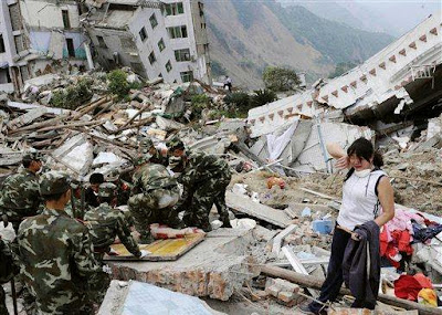
The 2008 Sichuan earthquake or the Great Sichuan Earthquake was a deadly earthquake that measured at 8.0 Ms and 7.9 Mw occurred at 14:28:01.42 CST (06:28:01.42 UTC) on May 12, 2008 in Sichuan province of China and killed at least 68,000 people.

It is also known as the Wenchuan earthquake (Chinese: 汶川大地震; pinyin: Wènchuān dà dìzhèn), after the location of the earthquake's epicenter, Wenchuan County in Sichuan province. The epicenter was 80 kilometres (50 mi) west-northwest of Chengdu, the capital of Sichuan, with a focal depth of 19 kilometres (12 mi). The earthquake was also felt in nearby countries and as far away as both Beijing and Shanghai—1,500 kilometres (932 mi) and 1,700 kilometres (1,056 mi) away—where office buildings swayed with the tremor.

Official figures (as of July 21, 2008 12:00 CST) state that 69,197 are confirmed dead, including 68,636 in Sichuan province, and 374,176 injured, with 18,222 listed as missing . The earthquake left about 4.8 million people homeless, though the number could be as high as 11 million. Approximately 15 million people lived in the affected area. It was the deadliest earthquake to hit China since the 1976 Tangshan earthquake, which killed at least 240,000 people, and the strongest since the 1950 Chayu earthquake in the country, which registered at 8.5 on Richter magnitude scale. It is the 21st deadliest earthquake of all time.

Strong aftershocks, some exceeding magnitude 6, continued to hit the area even months after the main quake, causing new casualties and damage.

On November 6, 2008, the central government announced that it will spend 1 trillion yuan (about $146.5 billion) over the next three years to rebuild areas ravaged by the earthquake.

http://world-worst-disasters.blogspot.com/

Thursday, August 5, 2010

2004 Indian Ocean earthquake and tsunami


2004 Indian Ocean earthquake
http://world-worst-disasters.blogspot.com/
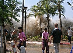
Tsunami strikes Ao Nang, Thailand.
DateDecember 26, 2004 (2004-12-26)
Magnitude9.1 Mw
Depth30 km (19 mi)
Epicenter location3°18′58″N 95°51′14″E / 3.316°N 95.854°E / 3.316; 95.854Coordinates: 3°18′58″N 95°51′14″E / 3.316°N 95.854°E / 3.316; 95.854
TypeUndersea (subduction)
Countries or regions affectedIndonesia (mainly in Aceh)
Sri Lanka
India (mostly in Tamil Nadu)
Thailand
Maldives
TsunamiYes
Casualties230,000+ (the fifth deadliest earthquake in recorded history)

The 2004 Indian Ocean earthquake was an undersea megathrust earthquake that occurred at 00:58:53 UTC on December 26, 2004, with an epicentre off the west coast of Sumatra, Indonesia. The quake itself is known by the scientific community as the Sumatra-Andaman earthquake. The resulting tsunami is given various names, including the 2004 Indian Ocean tsunami, Asian Tsunami, Indonesian Tsunami, and Boxing Day Tsunami.

The earthquake was caused by subduction and triggered a series of devastating tsunamis along the coasts of most landmasses bordering the Indian Ocean, killing over 230,000 people in fourteen countries, and inundating coastal communities with waves up to 30 meters (100 feet) high. It was one of the deadliest natural disasters in recorded history. Indonesia was the hardest hit, followed by Sri Lanka, India, and Thailand.

With a magnitude of between 9.1 and 9.3, it is the second largest earthquake ever recorded on a seismograph. This earthquake had the longest duration of faulting ever observed, between 8.3 and 10 minutes. It caused the entire planet to vibrate as much as 1 cm (0.4 inches) and triggered other earthquakes as far away as Alaska.

The plight of the many affected people and countries prompted a widespread humanitarian response. In all, the worldwide community donated more than $7 billion (2004 U.S. dollars) in humanitarian aid. The hypocenter occurred between Simeulue and mainland Indonesia.

http://world-worst-disasters.blogspot.com/

Tuesday, August 3, 2010

2010 Haiti earthquake

2010 Haiti earthquake
http://world-worst-disasters.blogspot.com/
Quake epicentre and major cities affected
Date16:53:10, 12 January 2010 (−05:00) (2010-01-12T16:53:10−05:00 21:53:10, 12 January 2010 (UTC) (2010-01-12T21:53:10Z)
Magnitude7.0 Mw
Depth13 km (8.1 miles)
Epicenter location18°27′25″N 72°31′59″W
Countries or regions affectedHaiti
Max. intensityMM X
TsunamiYes (localized)
Casualties92,000 - 230,000 deaths (6th deadliest earthquake)

The 2010 Haiti earthquake (Haitian Creole: Tranblemanntè 2010 nan peyi Ayiti) was a catastrophic magnitude 7.0 Mw earthquake, with an epicentre near the town of Léogâne, approximately 25 km (16 miles) west of Port-au-Prince, Haiti's capital. The earthquake occurred at 16:53 local time (21:53 UTC) on Tuesday, 12 January 2010. By 24 January, at least 52 aftershocks measuring 4.5 or greater had been recorded. An estimated three million people were affected by the quake; the Haitian Government reported that an estimated 230,000 people had died, 300,000 had been injured and 1,000,000 made homeless. They also estimated that 250,000 residences and 30,000 commercial buildings had collapsed or were severely damaged.

The earthquake caused major damage in Port-au-Prince, Jacmel and other settlements in the region. Many notable landmark buildings were significantly damaged or destroyed, including the Presidential Palace, the National Assembly building, the Port-au-Prince Cathedral, and the main jail. Among those killed were Archbishop of Port-au-Prince Joseph Serge Miot, and opposition leader Micha Gaillard. The headquarters of the United Nations Stabilization Mission in Haiti (MINUSTAH), located in the capital, collapsed, killing many, including the Mission's Chief, Hédi Annabi.

Many countries responded to appeals for humanitarian aid, pledging funds and dispatching rescue and medical teams, engineers and support personnel. Communication systems, air, land, and sea transport facilities, hospitals, and electrical networks had been damaged by the earthquake, which hampered rescue and aid efforts; confusion over who was in charge, air traffic congestion, and problems with prioritization of flights further complicated early relief work. Port-au-Prince's morgues were quickly overwhelmed with many tens of thousands of bodies having to be buried in mass graves. As rescues tailed off, supplies, medical care and sanitation became priorities. Delays in aid distribution led to angry appeals from aid workers and survivors, and looting and sporadic violence were observed.

On 22 January the United Nations noted that the emergency phase of the relief operation was drawing to a close, and on the following day the Haitian government officially called off the search for survivors.

1976 Tangshan earthquake

Tangshan Earthquake
http://world-worst-disasters.blogspot.com/
DateJuly 28, 1976 (1976-07-28)(China time zone)
Magnitude7.8
Epicenter locationTangshan, Hebei, China
Countries or regions affectedPeople's Republic of China
Casualties242,419 to 779,000 dead (2nd deadliest earthquake of all time)

The Tangshan Earthquake also known as the Great Tangshan Earthquake, was a natural disaster that occurred on July 28, 1976. It is believed to be the largest earthquake of the 20th century by death toll.[2] The epicenter of the earthquake was near Tangshan in Hebei, People's Republic of China, an industrial city with approximately one million inhabitants. The number of deaths initially reported by the Chinese government was 655,000, but this number has since been stated to be around 240,000 to 255,000. A further 164,000 people were recorded as being severely injured.[4] The earthquake came in between a series of political events involving the Communist Party of China. It shook China both literally and figuratively in 1976, which was later labeled a "cursed year".

The earthquake hit in the early morning, at 03:42:53.8 local time (1976 July 27 19:42:53.8 UTC), and lasted 23 seconds.Chinese government official sources state a magnitude of 7.8 on the Richter magnitude scale, though some sources listed it as high as 8.2. It was followed by a major 7.8 magnitude aftershock some 16 hours later, increasing the death toll.

Death toll

Controversial statistics

Until fairly recently, China's political environment has made it difficult to properly gauge the extent of natural disasters. Successive governments have placed more importance on the appearance of harmony rather than accurate information on damages. The Tangshan Earthquake came at a rather politically sensitive time during the late stages of the Cultural Revolution, making accurate statistics especially difficult to find. The Tangshan earthquake killed 242,419 people according to official figures, though some sources estimate a death toll up to three times higher. This would make it the deadliest earthquake in modern times, and the second or third deadliest in recorded history. It is worth noting that the population of Tangshan at the time the quake struck was estimated to be around 1.6 million. As most of Tangshan's city proper was flattened, it is reasonable to estimate the actual death toll to be much higher.

Many experts believe the Chinese government has never released an accurate death toll for the disaster. The death toll figure of 242,419 came from the Chinese Seismological Service in 1988, while some sources have estimated the death toll to be at 650,000. Others range as high as 700,000. The initial estimates of 655,000 dead and 779,000 injured were released by Hebei Revolutionary Committee.

Monday, August 2, 2010

1970 Bhola cyclone

Very severe cyclonic storm (IMD)
Category 3 tropical cyclone (SSHS)


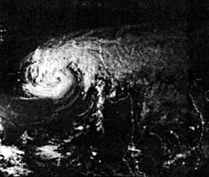
The Bhola cyclone on November 11, 1970, at 0858 UTC.
FormedNovember 7, 1970 (1970-11-07)
DissipatedNovember 13, 1970 (1970-11-14)
Highest winds
185 km/h (115 mph) (3-minute sustained)
205 km/h (130 mph) (1-minute sustained)
Lowest pressure966 mbar (hPa; 28.53 inHg)
Fatalities300,000–500,000 (Deadliest tropical cyclone of all time)
Damage$86.4 million (1970 >USD)$480 million (2010 USD)
Areas
affected
India, East Pakistan
Part of the1970 North Indian Ocean cyclone season

The 1970 Bhola cyclone was a devastating tropical cyclone that struck East Pakistan (now Bangladesh) and India's West Bengal on November 12, 1970. It was the deadliest tropical cyclone ever recorded, and one of the deadliest natural disasters in modern times.[2] Up to 500,000 people lost their lives in the storm, primarily as a result of the storm surge that flooded much of the low-lying islands of the Ganges Delta. This cyclone was the sixth cyclonic storm of the 1970 North Indian Ocean cyclone season, and also the season's strongest, reaching a strength equivalent to a Category 3 hurricane.

The cyclone formed over the central Bay of Bengal on November 8 and travelled north, intensifying as it did so. It reached its peak with winds of 185 km/h (115 mph) on November 12, and made landfall on the coast of East Pakistan that night. The storm surge devastated many of the offshore islands, wiping out villages and destroying crops throughout the region. In the most severely affected Thana, Tazumuddin, over 45% of the population of 167,000 was killed by the storm.

The Pakistani government was severely criticized for its handling of the relief operations following the storm, both by local political leaders in East Pakistan and in the international media. The opposition Awami League gained a landslide victory in the province, and continuing unrest between East Pakistan and the central government triggered the Bangladesh Liberation War, which concluded with the creation of the country of Bangladesh.

DEATH TOLL
ThanaPre-cyclone populationReported deathsMortality (%)
Kalapara88,0008,0009
Amtali41,0002,0005
Galchipa319,00045,00014
Char Fasson171,00038,00022
Lalmohan104,00023,00022
Tazumuddin167,00077,00046
Hatiya219,00018,0008
Ramgati>217,00024,00011
Sudharam35,0006,00017
Total1,361,000251,00017.7